


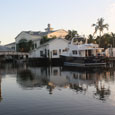


Located just minutes from the Intercoastal Waterway (ICW) and the Gulf of Mexico, Port Sanibel Marina is your one-stop, full service marina. Ideally situated at the southwestern tip of Lee County in beautiful Fort Myers, Florida, Port Sanibel Marina is only 20 minutes away from Southwest Florida International Airport.
Directions by land
Port Sanibel Marina is one mile East of Sanibel Island Causeway at the four-lane intersection of McGregor Blvd. and Port Comfort Rd.
Directions by water
Coordinates: 26′ 29.25 North 81′ 59.36 West.
The marina is located in a very sheltered harbor in Punta Rassa Cove. The entrance to the cove is marked by private markers on the east side of the channel across from Green marker 11, which is North of the Sanibel Causeway Bridge. The Marina is located at the end of the private channel on the left hand side, 1 mile from the main channel.
The Marina can also be approached from the Gulf through San Carlos Bay by going under the Sanibel Causeway Bridge. The Marina entrance channel is marked by a large Port Sanibel Marina sign, as well as day markers. The Channel maintains a depth of 5′. At mean low tide, expect a 2 1/2 foot tide in the basin.
The Marina staff monitors VHF Channel 16 and is on duty from 7:30am – 5:30pm


